Imagine yourself surrounded by the vast beauty of a wilderness, with no GPS or cell signal to guide you. How do you navigate through the untamed terrain? In this article, we will explore the top wilderness navigation techniques that will make you feel like a true explorer. From using a compass to reading topographic maps, these simple yet effective techniques will give you the confidence to venture into the great outdoors with ease and peace of mind. So grab your backpack and get ready to discover the secrets of navigating the wilderness like a pro.

Using a compass
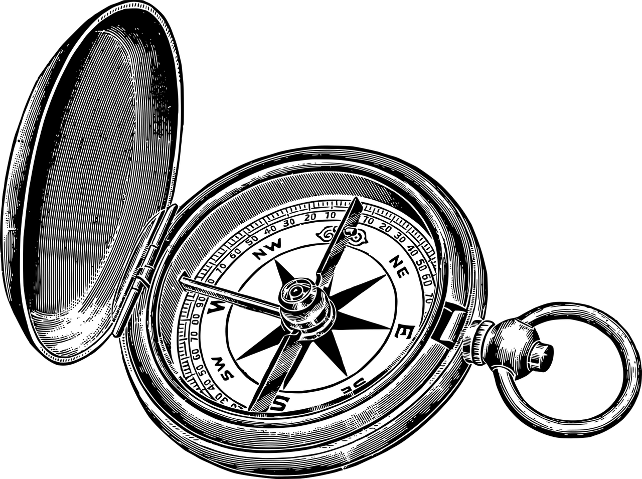
Understanding the basic parts of a compass
When it comes to wilderness navigation, a compass is an essential tool to have. Before you start using a compass, it’s important to understand its basic parts. A typical compass consists of a baseplate, a magnetic needle, a housing, and direction-of-travel arrows. The baseplate provides a flat surface to place on a map, while the magnetic needle aligns with the Earth’s magnetic field to indicate magnetic north. The housing contains the needle and is marked with cardinal directions such as north, south, east, and west. The direction-of-travel arrows help you determine your intended direction of travel.
Determining the direction of travel
Once you have a basic understanding of the compass’s parts, you can start determining the direction of travel. To do this, hold the compass flat in the palm of your hand. Then, rotate your body until the magnetic needle aligns with the north-facing arrow in the housing. This will give you an accurate sense of direction. It’s important to note that the needle points to magnetic north, which may deviate slightly from true north due to magnetic declination. Being aware of magnetic declination and adjusting your compass readings accordingly will help you navigate accurately.
Orienting the map with a compass
To effectively navigate with a map and compass, you need to orient the map in the same direction as the surrounding terrain. This process is known as orienting the map. To orient the map, place the compass on the map with the edge of the baseplate lined up with your desired direction of travel. Then, rotate the map and compass together until the magnetic needle aligns with the orienting arrow in the housing. This ensures that the map is aligned with the actual direction you will be traveling in.
Taking accurate bearings
Taking accurate bearings is crucial for navigating from one point to another. A bearing is the direction between two points measured in degrees. To take a bearing, align the straight edge of the compass with your starting point and the destination point on the map. Then, rotate the housing until the orienting arrow aligns with the north-facing arrow or the grid lines on the map. Read the bearing indicated on the compass housing. This bearing can then be used to maintain your desired direction while traveling, even without the need to reference the map frequently.
Reading a topographic map
Understanding contour lines
A topographic map is a detailed representation of the Earth’s surface, showcasing elevation changes through contour lines. Contour lines connect points of equal elevation, and understanding them is crucial for wilderness navigation. Contour lines that are close together indicate steep terrain, while lines that are farther apart depict gentle slopes. By analyzing the contour lines, you can anticipate changes in elevation and better plan your route. Additionally, contour lines may form circles, indicating hills or depressions, which can help you identify key topographic features.
Identifying key topographic features
To effectively navigate using a topographic map, it’s important to be able to identify key topographic features. These features may include mountain peaks, valleys, ridges, lakes, rivers, and other prominent landmarks. By pinpointing these features on the map, you can easily locate your position and determine which direction to travel next. Understanding the relationship between these features and the contour lines will give you a better understanding of the terrain and help you make informed navigation decisions.
Estimating distance and elevation
Topographic maps provide detailed information about distance and elevation. By using the map’s scale, you can estimate the actual distance between two points on the ground. Similarly, the contour lines on the map can help you estimate changes in elevation. Each contour line represents a specific elevation, and by counting the lines, you can determine how much the elevation changes. This information is crucial for planning your route and selecting the most suitable path based on your physical capabilities and the terrain’s demands.
Locating your position on the map
One of the primary purposes of a topographic map is to help you locate your position accurately. To do this, you can use various techniques. One method is called “triangulation.” By identifying at least three prominent landmarks or features in your surroundings, you can draw imaginary lines on the map from each landmark to your location. Where those lines intersect is your estimated position on the map. Another technique is known as “resectioning.” With resectioning, you choose a prominent feature that you can see on the ground and find it on the map. Then, using the compass, determine the direction to the feature. By drawing a line on the map from the feature in the direction indicated by the compass, the point where the line intersects with the feature on the map is your current position.

Navigating with GPS
Understanding GPS coordinates
With the advancement of technology, Global Positioning System (GPS) devices have become widely accessible for wilderness navigation. Understanding GPS coordinates is essential for utilizing these devices effectively. GPS coordinates consist of latitude and longitude, which are measured in degrees, minutes, and seconds. Latitude lines run parallel to the equator, with 0 degrees at the equator and 90 degrees at the poles. Longitude lines run from the North Pole to the South Pole, with 0 degrees at Greenwich, England. By inputting these coordinates into a GPS device, you can identify your exact position on the Earth’s surface.
Using GPS to plot waypoints
GPS devices allow you to plot waypoints, which are specific locations you want to navigate to or reference later. These waypoints can be landmarks, camping sites, water sources, or any other point of interest. By marking waypoints on your device, you can easily navigate back to those locations at any time. This feature is particularly helpful when exploring unfamiliar terrain or when retracing your steps on the return journey. Utilizing the waypoint function on a GPS device helps you maintain accuracy and confidence in your navigation efforts.
Following a GPS track
A GPS track is a recorded path that shows your movements over time. Following a GPS track is useful when you want to retrace your steps or navigate along a pre-planned route. By selecting a track on your GPS device, you can follow the route that you or others have previously traveled. This feature simplifies navigation and minimizes the risk of getting lost. However, it’s important to exercise caution and use other navigation techniques in conjunction with GPS, as relying solely on technology can have limitations and potential technical failures.
Using GPS for route planning
GPS devices can also be valuable tools for route planning. By accessing maps and routes on the device, you can explore the terrain, evaluate potential obstacles or hazards, and create a detailed plan before embarking on your journey. GPS devices often provide features such as elevation profiles and distance calculations, which allow you to customize your route according to your preferences and abilities. Utilizing GPS devices for route planning enables you to make informed decisions that optimize safety and efficiency in the wilderness.
Using landmarks
Identifying prominent landmarks
Landmarks serve as valuable reference points when navigating in the wilderness. These prominent features can be natural or man-made, and they can help you orient yourself and track your progress. Examples of natural landmarks include distinctive peaks, rivers, lakes, or unique geological formations, while man-made landmarks may include buildings, signs, or other structures. Identifying and memorizing these landmarks before setting out on your journey will enhance your navigation abilities and provide a sense of reassurance in unfamiliar terrain.
Using natural features as navigation aids
In addition to serving as landmarks, natural features can also be used as navigation aids. For example, rivers and valleys often offer clear routes through otherwise challenging terrain. Following these natural features can simplify navigation and help you reach your destination. Additionally, observing the flow of water or wind, the position of the sun, or the growth patterns of trees can provide valuable clues about your direction and surroundings. By developing a keen eye for the natural features around you, you can navigate more confidently and efficiently.
Creating mental maps with landmarks
Creating mental maps is a technique that involves memorizing key landmarks and their relationships to one another. By mentally visualizing these landmarks and their positions on the map, you can navigate without constantly referring to the map or compass. This skill allows for smoother and more intuitive navigation in the field. The more you practice creating mental maps, the more accurate and reliable your navigation skills will become. Furthermore, mental mapping enhances your spatial awareness and fosters a deep connection with the wilderness.
Navigating with a combination of landmarks and compass/map
While landmarks can be invaluable for navigation, combining them with a compass and map enhances your navigational accuracy. By triangulating between landmarks and using the compass to determine magnetic north, you can confidently gauge your direction of travel. Additionally, being able to cross-reference your location with the map ensures that you are on the right path. By incorporating both landmarks and compass/map navigation, you have a comprehensive approach that maximizes your chances of arriving at your desired destination.

Dead reckoning
Estimating distance and direction of travel
Dead reckoning is a navigation technique that involves estimating both distance and direction of travel without the aid of technology or external reference points. To estimate distance, you can use pacing and timing. By counting your steps and knowing your average pace length, you can estimate how far you have traveled. Additionally, using a watch or timer to measure the time taken to cover a specific distance can help in estimating your walking speed and making distance calculations.
Using pace count and timing to measure distance
To effectively use dead reckoning, it’s important to establish a consistent pace count. This involves counting your steps over a known distance and determining how many steps it takes you to cover that distance. By keeping a record of this measurement, you can then use your pace count to estimate distances in the field. Similarly, utilizing your timing ability to measure how long it takes you to travel certain distances provides another method for estimating distance. These techniques are especially useful when visibility is limited or when navigating dense vegetation where visual cues are scarce.
Adjusting for terrain features and obstacles
When using dead reckoning, it’s essential to adjust for terrain features and obstacles that may affect your estimated distance and direction. For example, steep slopes or uneven terrain may slow down your pace or alter your intended direction. Being aware of these factors and making adjustments to your navigation calculations will help you stay on track and avoid unnecessary detours. Regularly reassessing the terrain and comparing it to your surroundings on the map will allow you to navigate with greater accuracy.
Keeping track of your progress
To ensure that you are progressing along your desired route, it’s crucial to regularly keep track of your progress when using dead reckoning. This involves continuously comparing your estimated position and distance traveled with the features and distances recorded on your map. By periodically updating your position and cross-referencing it with landmarks or features in your surroundings, you can make any necessary adjustments to your navigation plan. Maintaining an awareness of your progress will prevent you from becoming disoriented and help you reach your destination efficiently and safely.
Using celestial navigation
Using the sun’s position and shadows
Celestial navigation is a technique that involves using the position of celestial bodies, such as the sun, to determine your direction of travel. The sun’s position in the sky changes throughout the day, and by observing its movement and shadows, you can estimate the general direction of east and west. In the morning, the sun rises in the east, and in the afternoon, it sets in the west. Shadows cast by objects can also provide valuable information about direction. By noting the direction of the sun’s movement and the length and direction of shadows, you can establish a sense of direction even without a compass or map.
Determining approximate time and direction
Celestial navigation also allows you to determine approximate time and direction using the position of the sun. By knowing the time of day and the general direction of east or west, you can estimate the positions of north and south. For example, if it is morning and the sun is in the eastern part of the sky, you can assume that south is directly opposite the sun. This approximation provides a sense of orientation and helps you navigate in the absence of other navigational tools. It’s important to note that celestial navigation requires clear skies and a basic understanding of celestial movements.
Navigating using the stars at night
During nighttime, when celestial bodies are more visible, stars can be used for navigation. By identifying specific constellations or stars and determining their positions in relation to the horizon, you can determine your general direction of travel. The North Star, also known as Polaris, is particularly useful in the Northern Hemisphere as it remains relatively fixed in the sky and aligns with the Earth’s axis. By locating the North Star and using it as a reference point, you can establish a sense of north, south, east, and west in the night sky.
Using constellations as reference points
To enhance your celestial navigation skills, it’s beneficial to familiarize yourself with constellations and their positions in the night sky. Identifying and memorizing key constellations can serve as reliable reference points for navigation. For example, the Big Dipper is a well-known constellation that can help you find the North Star. By tracing an imaginary line through the two outer stars of the Big Dipper’s “bowl,” you can locate the North Star, which points directly north. Understanding the positions and movements of constellations allows you to confidently navigate during nighttime in wilderness areas.

Navigating in poor visibility
Using a compass and a GPS in low visibility
Navigating in poor visibility, such as fog, heavy rain, or snow, can be challenging. In these situations, it becomes even more crucial to rely on navigational tools like a compass and GPS. A compass can provide a reliable sense of direction despite limited visibility, while a GPS can help you track your progress and locate your position with greater accuracy. By using these tools in combination and frequently cross-referencing your readings, you can navigate safely through challenging weather conditions.
Following a predetermined route or bearing
In low visibility situations, it is often safer to follow a predetermined route or bearing rather than attempting to navigate using visual cues alone. By pre-planning your route and marking specific waypoints or key landmarks, you can maintain your intended direction even in the absence of visible features. Additionally, setting a specific bearing on your compass and consistently referring to it will help you stay on course. Following a predetermined route or bearing ensures that you are less likely to become disoriented or risk wandering off in the wrong direction.
Using tactile navigation techniques
When visibility is poor, tactile navigation techniques can be highly effective. These techniques involve relying on your sense of touch and feel to navigate. For example, you can use your hands to feel the texture of the ground, trees, or rocks to gain a better understanding of your surroundings. This can be particularly valuable when combined with other navigation tools, such as a compass or map. Additionally, using your feet to detect changes in terrain or to feel for specific features can help you maintain your intended direction.
Implementing safety protocols in difficult conditions
Navigating in poor visibility conditions requires implementing additional safety protocols to minimize risks. It’s important to move at a slower pace, especially in unfamiliar terrain, to reduce the chances of accidents or getting disoriented. Staying vigilant and regularly checking your navigational tools will help you detect any deviations from your intended course. Communicating with your group or a trusted contact about your plans and progress is also essential. In challenging weather conditions, it’s advisable to have backup plans and alternative routes in case unexpected obstacles or hazards arise.
Route planning and preparation
Assessing the difficulty of the terrain
Before embarking on any wilderness journey, it’s crucial to assess the difficulty of the terrain you will be navigating through. Analyzing the elevation changes, the type of vegetation, and the presence of water sources or other obstacles will help you gauge the physical demands and challenges of the route. This assessment allows you to plan accordingly, considering factors such as endurance, equipment needs, and potential alternatives.
Identifying potential hazards and obstacles
Part of route planning is identifying potential hazards and obstacles along your intended path. This can include steep cliffs, river crossings, unstable terrain, wildlife habitats, or areas prone to extreme weather conditions. Having a clear understanding of these hazards allows you to take preventive measures, adjust your route if necessary, and prepare appropriate gear or skills to mitigate risks.
Choosing the best route and landmarks
After evaluating the terrain and potential hazards, it’s time to choose the best route for your journey. This involves selecting the path that minimizes risks and aligns with your abilities and objectives. Selecting prominent landmarks along the route will also enhance your navigation efforts. By choosing easily identifiable features, you can continually cross-reference your map, compass, or GPS to ensure you are on the right track.
Creating backup plans and alternative routes
One critical aspect of route planning is creating backup plans and alternative routes. It’s important to be prepared for unexpected circumstances, such as extreme weather, blocked trails, or injuries. By identifying alternative routes or safe areas to retreat to, you can adapt your plans and ensure the safety of yourself and your group. Having backup plans in place reduces the chances of being stranded or lost and allows for flexibility and adaptability during your wilderness exploration.

Using a map and compass together
Using the compass to orient the map
To effectively use a map and compass together, it’s essential to orient the map using the compass. By placing the compass on the map and aligning the orienting arrow with the north arrow, you ensure that the map is correctly aligned with the actual directions of the terrain. This enables you to accurately identify your destination, locate landmarks, and plan your route based on the map’s features.
Using the map to identify landmarks
A map provides a wealth of information about the terrain and its features. By studying the map, you can identify specific landmarks along your intended route. These landmarks may include mountain peaks, lakes, rivers, or distinctive geological formations. By cross-referencing your surroundings with the map, you can verify your location and progress, helping you stay on course.
Implementing the compass/map combination for accurate navigation
The combination of a compass and map is a powerful tool for accurate navigation. By utilizing the compass to determine your direction of travel and the map to identify landmarks or features, you can confidently navigate through the wilderness. Regularly cross-referencing your readings and verifying your position on the map ensures that you remain on the desired route and reach your destination safely.
Accounting for magnetic declination
Magnetic declination refers to the difference between true north and magnetic north. It’s important to account for magnetic declination when using a compass and map together. By adjusting your compass readings or map orientation, you ensure that your navigation is accurate and aligned with the true direction. Understanding the specific magnetic declination for your location and adjusting your compass accordingly minimizes errors and helps you maintain precise navigation.
Practicing wilderness navigation
Taking navigation courses and workshops
Practicing wilderness navigation is essential for honing your skills and building confidence. One way to improve your abilities is to take navigation courses or workshops. These courses provide instruction on using maps, compasses, GPS devices, and other navigation tools. They also offer opportunities to practice navigation techniques in a controlled environment under the guidance of experienced instructors. Taking navigation courses and workshops helps you develop a solid foundation of skills and knowledge that can be applied in the field.
Practicing navigation skills in a controlled environment
While learning in a classroom or workshop setting is valuable, it’s crucial to apply your navigation skills in a real-world environment. This can be done by practicing in a controlled setting, such as a local park or wilderness area. By starting with simpler routes and gradually increasing difficulty, you can familiarize yourself with different navigational challenges and gain practical experience. Practicing in a controlled environment allows you to refine your techniques, assess your progress, and identify areas for improvement.
Gradually increasing difficulty and complexity
To continually improve your wilderness navigation skills, it’s important to gradually increase the difficulty and complexity of your practice routes. As you become more proficient, you can explore unfamiliar terrains, navigate off-trail, or plan multi-day wilderness trips. By progressively challenging yourself, you develop a wide range of skills and gain confidence in your ability to navigate through diverse environments. However, it’s essential to always prioritize safety and ensure you have the necessary knowledge and equipment for each new level of difficulty.
Building confidence in your navigation abilities
Building confidence in your navigation abilities is a gradual process that takes time and practice. By consistently applying and refining your skills, you will develop a strong understanding of navigation principles and techniques. Over time, you will become more comfortable and self-assured when venturing into the wilderness. Confidence allows you to navigate with greater ease, enjoy the journey, and fully immerse yourself in the wonders of the natural world.
In conclusion, wilderness navigation requires a combination of skills, tools, and techniques. Understanding the basic parts of a compass, reading topographic maps, utilizing GPS devices, identifying landmarks, using dead reckoning, employing celestial navigation, navigating in poor visibility, and practicing route planning are all key components for successful wilderness navigation. By mastering these techniques and regularly practicing them in different environments, you can confidently explore the wilderness and safely reach your desired destinations. Remember, navigation skills are not only practical but also enriching, as they deepen your connection with nature and allow for a more immersive wilderness experience.